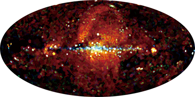
MAXI/SSC all-sky maps
The All-sky X-ray maps made by Nakahira et al. (2020), accumulated from the Solid-state Slit Camera (SSC) on board the MAXI mission for 2 years from 2009 to 2011. They are the first ones that were derived with a solid-state instrument.

| Creation Date | Energy (keV) | PI Channel | Data Files |
|---|---|---|---|
| 20191202 | 0.7-1.0 | 192-273 | FITS |
| 20191202 | 1.0-2.0 | 274-547 | FITS |
| 20191202 | 2.0-4.0 | 548-1095 | FITS |
NOTES
Primary Header
Binary image presented in the Aitoff-Hammer projection and the Galactic coordinates.
Secondary Header
HEALpix image in Equatorial coordinates where ORDERING=NESTED and NSIDE=128 are used.
Request for using this data
In addition to the "Requests when using MAXI Data", please cite the paper:
"MAXI/SSC All-sky maps from 0.7 keV to 4 keV", Nakahira, S. et al., PASJ, Volume 72, Issue 2, id.17 (2020) [doi:10.1093/pasj/psz139] [arXiv:1912.01572]


